
What wms & tile layers does
- Paste a WMS address and pick one of the server's layers
- XYZ tile URLs with {z}/{x}/{y}, {s} subdomains, {-y} and WMTS REST templates
- ArcGIS MapServer and ImageServer, with cached tiles or images drawn on the fly
- Check test-loads the overlay and previews it before you save
- Opacity slider, so the base map shows through
- Sits on top of the base map and under your pins and shapes, and stays on when you switch base map
- Servers that block other websites still work, passed through GeoMaps automatically
See-through aerial imagery
Add a tile URL, here public USGS aerial imagery, then drag the opacity slider until the streets show through. Switch to the dark base map and the overlay stays on.
An ArcGIS MapServer as imagery
Paste an ArcGIS MapServer address, like the USGS topographic map, and GeoMaps draws it as an overlay using the service's own tiles.
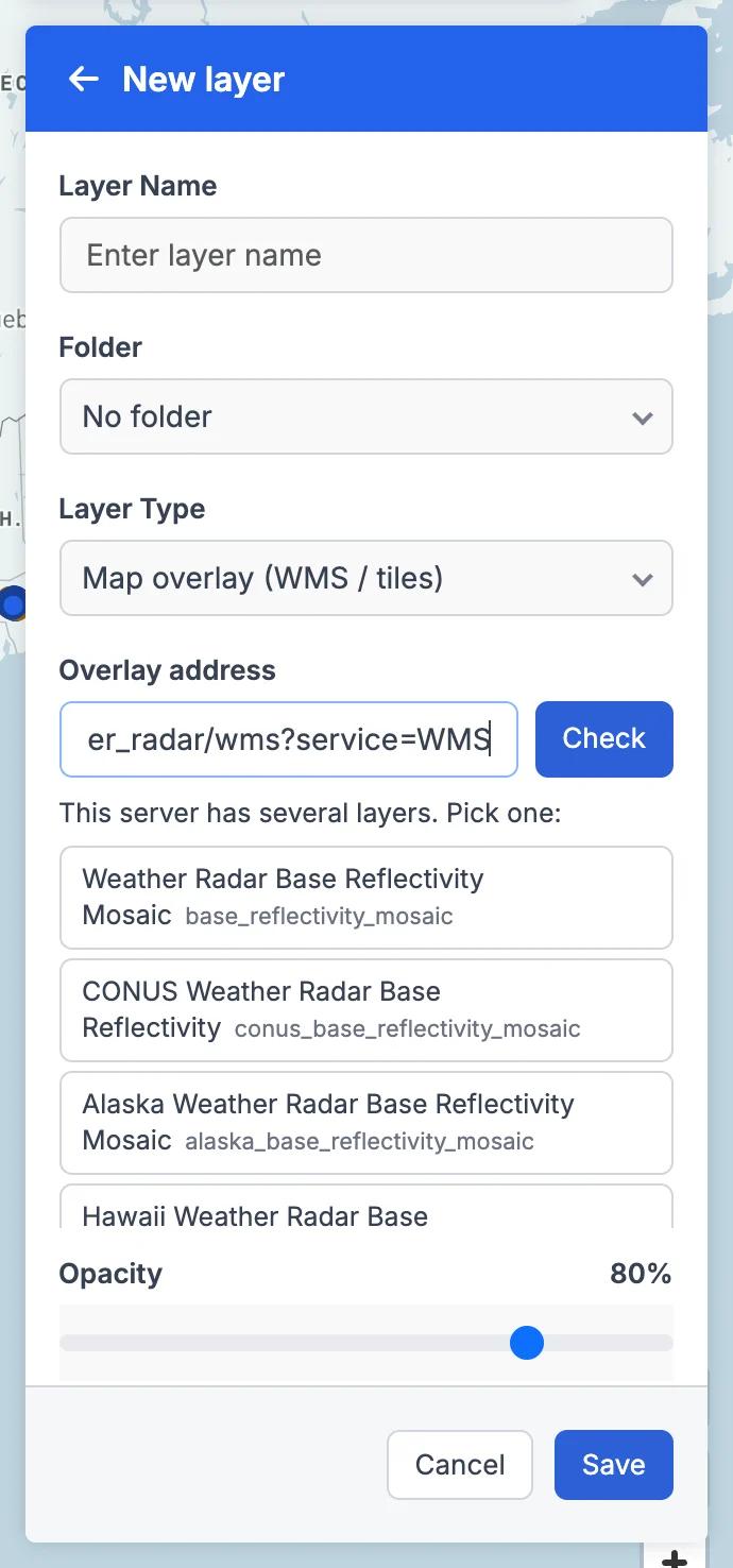
Pick a layer from a WMS server
Paste a WMS address and click Check. GeoMaps lists the server's layers, here NOAA's weather radar mosaics, so you can choose the one you want.
WMS & Tile Layers in GeoMaps
Plenty of useful maps are published as imagery rather than data: live weather radar, aerial photos, topographic maps, flood and hazard maps, or a city's zoning map. With WMS & Tile Layers you can put any public one on your map, right under your own customers and territories, so you see both at once.
In the Layers panel, choose New layer and the layer type "Map overlay (WMS / tiles)". Paste the overlay address and click Check. GeoMaps loads a test image and previews the overlay on your map, then you click Save. A WMS address lists the server's layers so you can pick one; a tile URL with {z}/{x}/{y} works as is (with {s} subdomains, {-y} and WMTS REST templates too); and an ArcGIS MapServer or ImageServer uses the service's cached tiles when it has them and draws images on the fly when it doesn't.
Each overlay has its own opacity slider, so the streets and labels below can show through, and it stays on when you switch base map. Some servers don't let other websites draw their images directly; GeoMaps passes those through its own server automatically, so they still work without any setup (they appear once you save).
An overlay is a picture of someone else's map. It stays live, so radar shows the current weather, but you can't click it for details or use it in filters. If you need the shapes and their data, use ArcGIS Layers instead.
Need the shapes and their data, not just a picture? See ArcGIS Layers →
It's part of GeoMaps' tools tools, so it works hand in hand with the rest of your map.
Where wms & tile layers helps
Weather for field service and insurance
Overlay live weather radar on your jobs or policyholders to see which customers sit under a storm and plan crews or outreach around it.
Aerial imagery and flood maps
Check sites against aerial photos, or lay a public flood or hazard map over properties for insurance and real estate work.
Topographic and local GIS maps
Use topographic maps for agriculture and outdoor work, or a city or county GIS server's zoning or parcel imagery for planning.
WMS & Tile Layers FAQ
- What addresses can I paste?
- A WMS server address (GeoMaps reads its capabilities and lists the layers to pick from), an XYZ tile URL with {z}/{x}/{y} (also {s} subdomains, {-y} and WMTS REST templates), or an ArcGIS MapServer or ImageServer.
- Does GeoMaps provide the weather, imagery or flood data?
- No. GeoMaps shows imagery from a public server that you paste. Many government agencies and organisations publish free WMS or tile services you can use.
- Can I click an overlay to see details or filter by it?
- No. An overlay is a picture of another map, so it has no clickable features or attributes. To bring in shapes with their data, use ArcGIS Layers.
- Are there any limits?
- Only public servers work for now, with no sign-in or API key prompts. Overlays show in the web app; the mobile app doesn't show them yet.