GeoMaps logoGeoMaps
Changelog

What's new in GeoMaps

New features and improvements across the GeoMaps web app and the iPhone and Android apps.

  1. Bigger shared maps and smarter imports

    Shared maps can now carry a whole territory plan in one link, and spreadsheets with split address columns are set up for you on import.

    Up to 100 lists and layers on a shared map

    A shared map can now include up to 100 lists and layers, up from 20. Share a complete territory plan, every rep's accounts or a full set of service areas in a single link, and viewers can still switch each one on and off.

    Split address columns detected on import

    When a spreadsheet keeps the address in separate Street, City, State and ZIP columns, GeoMaps now recognises it and maps each column automatically, so the file is ready to geocode without any manual field mapping.
  2. Team-wide layers and “is any of” filters

    Territories you draw are now shared with your whole team, and text filters can match a list of values in one step.

    Layers are shared across your workspace

    Territories, service areas and imported shapes now belong to the workspace instead of the person who created them. Everyone on the team sees the same layers and can edit them, the same way lists already work. Which layers are switched on stays personal, so your view isn't changed by a teammate's.

    “Is any of” and “is none of” for text fields

    Filter a list by several values of a text field at once, such as owner is any of Sarah, Miguel or Priya, or status is none of Lost or Closed. GeoMaps suggests the values that exist in your data, and the same filter works on the web, in the mobile app and on shared maps.

  3. GeoMaps for Android

    The mobile app is now on Google Play, and lists filtered by territory open much faster.

    GeoMaps for Android

    The GeoMaps mobile app is now available on Google Play as well as the App Store. Sign in with your GeoMaps account to see your lists, layers and routes on the go, look up any record, and update it from the field.

    Faster territory filters

    Lists filtered by “inside layer” (for example, accounts within a sales territory) now open, sort and page through the table almost instantly, even across tens of thousands of records.

    Improvements

    • OnePageCRM: contacts are imported for your whole team, not only the connected user, and “Open in OnePageCRM” goes straight to the contact.
    • Records placed by latitude/longitude columns move on the map as soon as their coordinates change in your source.
  4. AgencyZoom integration and appointment mapping

    Insurance agencies can now map their AgencyZoom book of business, and LeadConnector appointments can be mapped where they happen.

    AgencyZoom integration

    Connect AgencyZoom to put your leads and customers on a map, colour them by status or producer, and plan visits. Changes you make in GeoMaps sync back to AgencyZoom.

    Map LeadConnector appointments

    Appointments can be placed at their own meeting address or at the contact's address, and their start times come through as columns you can filter and sort by. That makes it easy to see tomorrow's visits on a map and route between them.

    Improvements

    • Route PDFs print stop numbers cleanly on routes with 10 or more stops.
    • Capsule: contacts with several addresses use the right one for their pin.
    • Google Sheets: syncs retry automatically when Google is briefly unavailable, and a renamed or deleted tab is reported clearly.
  5. Share live maps with a link

    Share exactly the map you're looking at, with full control over what viewers can see and do.

    Shared maps

    Share your current map view as a link. Pick the lists and layers to include, the basemap and starting view, and whether viewers get search, the list panel, the layers panel or the table. Viewers explore a live, read-only map that stays in sync with your data, with no account needed.

  6. Edit from the map, and GeoMaps for iPhone

    Update your data where you see it, on the desktop or in the field, and keep your source in sync.

    Edit records from the map

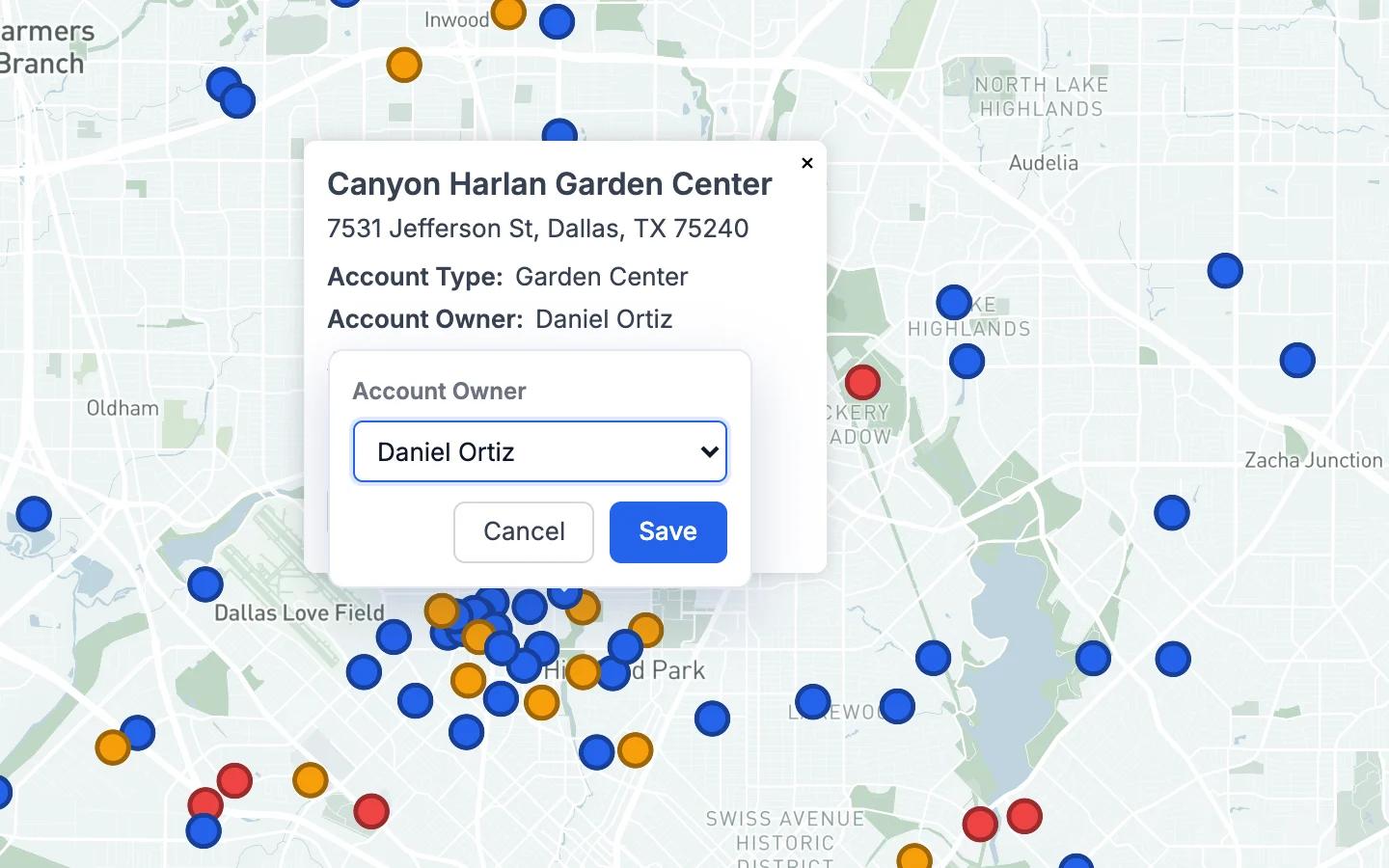
    Change a field right in a marker's popup, edit many rows at once in the table, drop a new marker to add a record, or save a prospect straight into a dataset. Edits sync back to Google Sheets, your GeoMaps datasets and supported CRMs such as Copper, Nimble, Salesmate and AgencyZoom.

    Editing a record's fields in its map popup

    GeoMaps for iPhone

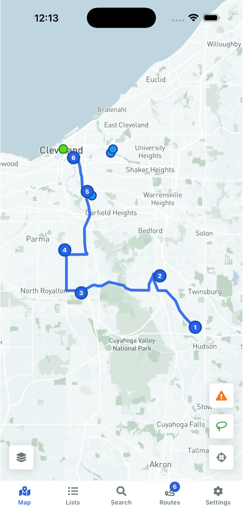
    The GeoMaps app is on the App Store. See your lists and layers on a native map, search records, follow your routes and update records or add new ones on site. Sign in with your GeoMaps account, Google or Apple.

    A planned route with numbered stops in the GeoMaps iPhone app

    Improvements

    • Route CSV exports now include separate Street, City, State, ZIP and Country columns, ready for mail merge and label printing.
  7. Table view

    Every list now has a spreadsheet-style table right under the map.

    Table view

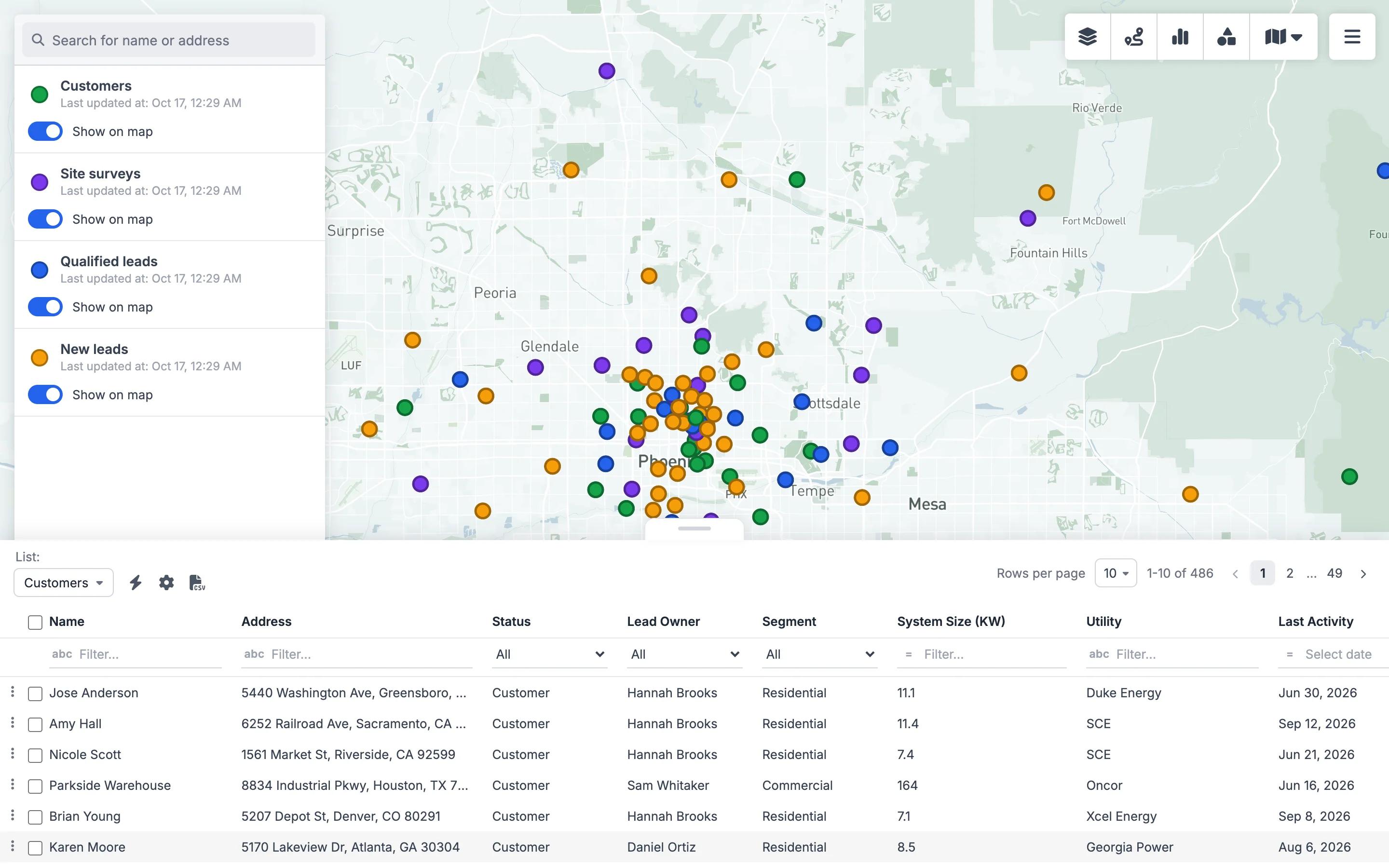
    Open any list as a table without leaving the map. Sort and filter each column, choose which columns to show, export to CSV, and select rows to add them to a route. Click a row to jump to it on the map. The table and the map always show the same filtered records.

    A list of solar leads shown as a filterable table under the map

    One marker per record

    When a record belongs to several lists, it's now drawn once, in the colour of the most specific list, instead of as stacked markers. Maps look cleaner, and heatmaps and clusters count every record once.

    Improvements

    • Less Annoying CRM: custom fields and groups are imported, so you can colour and filter by them.
    • Attio: related records, such as a company's deals or people, appear in the popup with links, and lists can be filtered by a linked record's fields.

Put your first map together in 10 minutes.

Free forever for 1,000 locations. No credit card required.